Search results
Jump to navigation
Jump to search
Help • Search categories • Show other tools
|
Help
|
|
Browse
|
Search
|
There is a page named "South Dakota" on this wiki
 0 Creative Commons Attribution-Share Alike 4.0 truetrue English Jaw and teeth of a Oreodon (''Merycoidodon culbertsoni''), South Dakota, United States...(7,736 × 5,192 (7.94 MB)) - 19:24, 8 April 2024
 0/PDMCreative Commons Public Domain Mark 1.0falsefalse English American Rescue Plan Fact Sheet: Impacts on South Dakota determination method: SHA-1...(1,275 × 1,650 (170 KB)) - 14:21, 6 August 2023
 The Battleship USS South Dakota, Public domain photo from history.navy.mil Removed caption read: Photo # NH 97265 USS South Dakota in the Hvalfjordur...(5,225 × 4,182 (7.51 MB)) - 10:13, 15 April 2024
 English Flag of South Dakota, United States of America. Turkish Güney Dakota bayrağı British English Flag of South Dakota, United States of America. Russian...(720 × 450 (206 KB)) - 16:53, 12 December 2023
 in South Dakota. Transwiki approved by: w:en:User:Dmcdevit This image was copied from wikipedia:en. The original description was: w:en:Category:South Dakota...(764 × 584 (84 KB)) - 13:07, 10 January 2023
 January 2019 South Dakota State Constitution English determination method: SHA-1...(825 × 1,200 (595 KB)) - 17:31, 12 April 2024
 0/PDMCreative Commons Public Domain Mark 1.0falsefalse English Guide to Public Vital Statistics Records in South Dakota, South Dakota Historical Records Survey...(2,013 × 1,610 (1.27 MB)) - 03:46, 14 September 2023
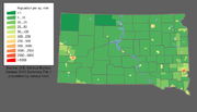 bytes) [[Category:U.S. State Population Maps]] [[Category:South Dakota maps]] South Dakota state population density map based on Census 2000 data. See...(700 × 400 (77 KB)) - 09:54, 4 August 2021
 original description was: map showing the density of South Dakota's counties. This map comes from the U.S. Bureau of Census. w:en:Category:South Dakota maps...(395 × 252 (6 KB)) - 08:14, 9 September 2017
 English South Dakota suffragists...(1,200 × 844 (115 KB)) - 03:39, 10 December 2022
 English EF2 tornado damage to a home south of Gary, South Dakota. heading: 280.42 degree...(3,024 × 4,032 (1.07 MB)) - 05:00, 24 November 2023
 English South Dakota suffragists...(1,200 × 852 (109 KB)) - 03:39, 10 December 2022
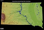 of South Dakota. From the United States Geological Survey (USGS) Source: http://edc.usgs.gov/imagegallery/imageDetail.php?page=16 &img+South+Dakota...(500 × 343 (49 KB)) - 09:52, 4 August 2021
 0/PDMCreative Commons Public Domain Mark 1.0falsefalse English Map with Fay Tolton Site, South Dakota Danish Kort med Fay Tolton Site, South Dakota...(1,366 × 768 (219 KB)) - 22:06, 24 March 2024
 Public Domain Mark 1.0falsefalse English Kort over Phillips Ranch site (39ST14), South Dakota Danish Kort over Phillips Ranch site (39ST14), South Dakota...(1,011 × 1,314 (1.99 MB)) - 00:42, 22 July 2023
 English Approaching dust storm in South Dakota, 1934....(800 × 500 (84 KB)) - 06:01, 26 May 2023
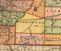 English 1892 map of South Dakota showing Washington County...(520 × 436 (600 KB)) - 04:51, 7 January 2020
 English South Dakota Messenger October 8, 1914...(519 × 576 (526 KB)) - 05:07, 12 July 2022
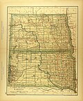 English 1894 Map of North and South Dakota...(2,928 × 3,566 (2.75 MB)) - 12:50, 21 June 2023
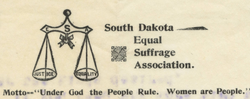 English South Dakota Equal Suffrage Association letterhead...(768 × 303 (273 KB)) - 18:03, 9 January 2023
,_Dakota_del_Sur,_Estados_Unidos,_2021-01-15,_DD_162-186_FS.jpg)
_anchored_in_Hvalfj%C3%B6r%C3%B0ur,_Iceland,_on_24_June_1943_(NH_97265).jpg)


